

Weather Forecast Decision Making
This article considers planning and decision making when considering the weather as part of preparation and planning for any flying you intend to do. It is not intended to be a refresher guide on aviation meteorology, for that there are some excellent groundschool refresher courses you can book, nor is it a replacement for your groundschool Met notes.
Instead, it provides some key thoughts on how to practically approach weather planning and decision making. When you are next grounded (due to the weather!), why not dig out those old groundschool notes and have a reread of them, you can never know enough about the changeable UK weather…
Weather decision making starts a long time before getting to the aircraft….
In practical terms, when we consider the weather, we can split our decision making down into two phases: 24-48 hours before the flight and the ‘on the day’ pre-flight planning.
Phase 1: 24-48 Hours to go
In the few days before any planned flight, it’s a good idea to look at the weather and make a generalised decision about whether we decide to ‘continue’ the flight, ‘cancel’ it, or make it a ‘maybe’.
At this stage, the general synoptic situation and likely general weather conditions will be our main sources. The Met Office and TV weather forecasts use advanced computer models which are relatively accurate out to a few days. If there is likely to be widespread rain, low cloud, poor visibility, or strong winds, this may well be an obvious threat to going flying. There are many sources of Met information available, common ones can be the Met Office App or the Met Office Aviation Briefing Service which is a (free sign-up) weather service that provides a wealth of aviation weather information for GA pilots.
As an example, the Met Office app shown below may give us relatively good confidence of achieving a good weather flight on the Tuesday, so that would remain as a ‘continue’. But the Wednesday situation would alert us to the need to pay close attention to cloud conditions and may result in an early ‘cancel’ decision.


Our decision will also be heavily influenced by the nature of the intended flight. If we are going to be flying new or nervous passengers, an early decision to delay for a better weather day might be fairly easy to make. In contrast, if it were just a solo local flight for our own currency, we may be more content to wait and decide on the day as it is no inconvenience whether we fly or not.
The ‘maybe’ decision outcome is an important one, as it allows us to try and avoid the ‘confirmation bias’ human factors trap. If we have already pre-conditioned our thinking to the fact that our intended flying trip may have to be cancelled or modified, we are perhaps less likely to try and convince ourselves on the day that ‘it will be ok’ when it isn’t. It also gives us time to replan some alternatives, that long trip over the sea may not be possible due to probable sea fog, but a local inland land-away to meet a friend may be a good backup plan.
As examples, a nice uncomplicated slack isobar situation like the picture to the right may give us confidence of a nice winter flying day.
Alternatively, the light winds may bring a risk of mist and low cloud that may warn us we need to carefully check the cloud bases on the day. In summer, a similar situation may need careful consideration due to the risk of low-level haze and poor visibility.
Spaced isobars, significant frontal movements, troughs, and other phenomena marked below (or other app-generated warnings), are key indicators that the weather will need some close consideration.

This (image above) was a 2012 low pressure system that brought heavy rain, strong winds and flooding to the UK - the most intense to cross the UK in September for more than 30 years, with the lowest air pressure of 973mb being recorded. Had you been planning to fly that day, the amount of activity shown on the synoptic chart would have been a key indicator to really pay attention to the weather.
As the synoptic chart is a major part in the weather decision making process, one as busy as this would result in a ‘maybe’ or ‘cancel’ decision with 48 hours to go, so at the very least, you are thinking about the weather before you arrive at the airfield.
Phase 2: On the day Pre-Flight planning
On the day of our intended flying trip, and considering our intended flight profile, we now need to look at the weather to refine our decision into whether we decide to ‘go’ or ‘no go’. Our information should be scoped appropriately. A long landaway may need very detailed inspection of departure, en route, destination and alternate weather conditions over a long time period, whereas for a very local trip, consideration of the local weather and a possible diversion airfield may suffice.
We may wish to consider our weather decision against the following factors. Expand each element by clicking on the arrows:
-
You should establish what the likely cloud base and ceiling will be at all different points of your flight. When considering your ability to remain in visual conditions at a given altitude, consider what the cloud cover is reported as or forecast to be and whether it may lower during the flight.
Remember to compare the cloud height figures at aerodromes with nearby terrain. TAFs and METARs give cloud levels in height above aerodrome elevation. A 1500 ft cloud ceiling could be shrouding the tops of nearby hills.
VFR flight with a cloud ceiling of 1500 ft or less above ground level (AGL) warrants special attention to terrain and obstacles. VFR flight below 1000ft AGL is generally only suitable for circuits or very local flying in areas you are familiar with.
-
You need sufficient in-flight visibility to control the aircraft visually, navigate and avoid other aircraft. The F215 chart and TAFs/METARs will give an indication of surface visibility but remember, actual in-flight visibility can be worse while in the air due to haze or flying into sun.
VFR flight in Class G airspace the UK below 3000ft AMSL and below 140kts is legal with only 1500m visibility. However, these would be very challenging conditions and VFR flight when the surface visibility is being reported as less than 5 km is not recommended. You are unlikely to have a clear horizon with which to control the aircraft and navigating visually will be very difficult.
-
You should consider the likely wind for all runway directions you plan to use and how current you are in crosswind landings if strong wind conditions are forecast. Crosswind landings, particularly in tailwheel aircraft, are one of the more perishable piloting skills and you may wish to consider your own personal limits for this.
High winds aloft are not in themselves hazardous, but winds above 35kts or so are often indicative of bumpy conditions meaning that maintaining an accurate height and heading may be challenging. It is also important to take account of strong headwinds when calculating fuel requirements.
-
A whole range of phenomena can bring significant hazards which may need avoiding action or even consideration as to whether it is sensible to fly in the first place. Particular care should be taken if thunderstorms, fog, snow, icing, or significant turbulence are forecast. Take care to fully consider these threats even if they are PROB30 or PROB40 forecast elements.
So how best to obtain the detailed information to make our final decision?
The best way to make your go, no go decision is to use the following:
· Met office F215 Low Level Aviation Area Forecast
· Met Office F214 UK Low Level Spot Wind Chart
· TAFs and METARS for your base airfield, local area, and destination airfield (if applicable)
Met Office F215 Low Level Aviation Area Forecast
In your flying training, you would have been very familiar with the Met Office F215 Forecast Weather chart. Since qualifying, and especially with ready access to other apps and sources, you may have become less inclined to obtain this chart. However, there is a huge amount of useful information and it gives an excellent overall appreciation of the weather conditions of the day. Frontal movements, potential weather phenomena, likely visibility, cloudbases and freezing levels are all relatively easily found. Do however, make sure you check when the front/zones are valid for and relate that to your intended flight time.


Met Office F214 UK Low Level Spot Wind Chart
This shows the forecast wind at various altitude and also shows the predicted temperatures. While much of the wind information can be provided for your route by automated apps, this chart is still very good for getting an overall appreciation of the weather factors affecting us on the day. Very strong winds at altitude, that could affect our navigation or bring turbulent conditions, may be masked by relatively benign surface winds as shown in METARs and TAFs, and this chart can be a way of picking that up. The F214 is often forgotten, but extremely useful.
Both the F214 and F215 are available via free to sign up to Met Office Aviation Briefing Service.
Terminal Aerodrome Forecasts and Meteorological Terminal Aviation Routine weather report (TAFs and METARs)
Are you completely comfortable with decoding TAFs and METARs? If not, why not undertake a quick refresher on a bad weather day, the more familiar you are with them then the easier it will become to interpret them. In terms of getting hold of them, mobile phone apps can provide very ready access to METAR and TAF data. This can be especially useful when away from full internet wi-fi and only able to access mobile phone data. However, make sure you always check the time/date of published information and the validity period, and make sure you refresh the page every time before reviewing them to avoiding planning on out-of-date information.
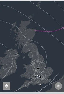
In the example below, it may look a reasonable night for night flying near Birmingham, but closer inspection reveals a risk of some nasty freezing fog and the METAR is also showing some snowfall and a closely matched temperature and dewpoint. Time to stay on the ground with a coffee and plan for another night!


Many of the common ‘Electronic Flight Bag’ and VFR Planning apps and software programmes integrate a number of weather information sources and information displays into their flight planning and in flight displays. The amount of data sources now available, and the speed of which it is updated, is hugely impressive and gives pilots more information at their fingertips than ever before.
However, it is important that pilots understand exactly what and how the information is being displayed to them. If colour codes or other symbols are being used to display weather conditions, it is also important to understand what parameters are being used on those and whether they are aligned to what you would consider suitable or not.
The final decision
When you have made your decision to ‘go’, it is time to focus on (and enjoy!) your other pre-flight checks and aircraft operation. However, if you experience delays for any reason, it is always worth taking the time to have another quick recheck that the weather hasn’t changed and that it is still suitable, especially now we can so easily access information on our phones and devices.
During the flight, maintain a close eye on weather conditions and ask yourself whether they are as expected from your planning. If you start to experience an unexpected deterioration, don’t delay in deciding to divert, return or modify your plan accordingly.
After your flight, it’s always worth carrying out an informal self-debrief, perhaps even just a few moments reflection on the drive home or after putting the aircraft away. Was the weather as I thought? If not, how did I miss it? Or was I unlucky to be caught out by an un-forecast change? What could I do differently next time?
If only we could get blue skies and light winds every time we wanted to fly!